Bizarre Geologic Landmarks of Oregon
Published 02/11/2010
 |
| The Columbia Gorge |
(Portland, Oregon) – From the Columbia Gorge, the Willamette Valley and Eastern Oregon to the coast, Oregon and the Northwest United States is a lot freakier than you’ve probably imagined. You need only dig a little (quite literally).
The forces that shaped this state were often unlike anywhere else in the world. Many of them were sudden and extremely violent, leaving bizarre, surreal objects to look at. Even those things of beauty we all rush to as tourists and sightseers have a wild, weird tale to tell – tales that are frequently frightening, but certainly surprising.
Columbia Gorge and Its Scary Past
Imagine 300 or so miles of volcanic lava, searing its way over forests and hills, sometimes pooling up into large masses of molten rock; moving slowly in a deadly march from a big hole in the Earth until it reaches the ocean.
This was the northwest U.S. some 16 million years ago, as a series of basalt flows scoured everything in its path in several such eruptions over millions of years. It created so many of the landmarks in Oregon and Washington we know of today, like Silver Falls State Park and the Columbia Gorge. It all came from a crack in the Earth’s crust around what is now western Idaho, and it slowly singed its way across this land until hit the coastline, where it either helped create such Oregon coast landmarks as Tillamook Head and the pillow basalts of Depoe Bay – or it veered underground, only to pop up back again in secondary eruptions that formed things like Haystack Rock at Cannon Beach.
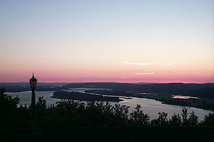 |
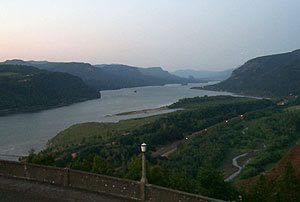
| The Gorge was carved out of a cataclysmic flood - millions of years after a massive lava flow created it. |
That crack in the crust still exists, but due to millions of years of plate movement has moved east to create what we now know as Yellowstone National Park.
After these basalt flows created part of what we know as the Columbia Gorge (this is only half the story for the Gorge), thousands of eruptions continued, which piled ash and mud onto the surface of the northwest. Over time, lots of this has eroded away as well, leaving beige formations in the cliffs near Bonneville Dam., or the reddish clay around Stevenson, Washington.
Then, some 10,000 to 15,000 years ago, during the Ice Age, another bizarre and rather unique geologic catastrophe happened in this area – which to this day is particular to this area of the world alone. In the Missoula, Montana area, a great ice dam formed, which held a near ocean of water behind it. Perhaps dozens, even hundreds of times, this dam broke, letting loose more water at speeds so high and volume so large it’s nearly inconceivable. It’s called the Missoula Flood, and it means this mega flood was so huge it carved out the basalt rock of the Columbia Gorge and other odd features in southern Washington in one massive, rather quick swoop.
Instead of a slow, erosion-like process, like most geologic means of change, this one happened nearly instantly. And it happened numerous times. The result was towering walls over the Columbia River we now see, and telltale ridges and lines near the tops of these walls that indicate numerous grand floods over time, where each flood carved its mark into the ancient rocks.
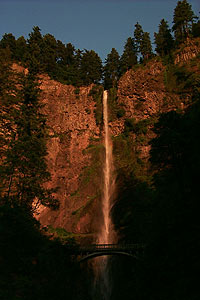 |
| Multnomah Falls, in the Gorge |
In southern Washington, there’s what is known as the “Scablands,” where puzzling holes ten feet or more in diameter dot an apparently scarred landscape. It took scientists decades to prove this, but it turns these odd valleys and structures in the Scablands are really just a giant riverbed – one so massive in scale it’s measured in miles rather than feet.
The Missoula Flood was so immense and fierce it created enormous “pits” along its path, much like water in a river or creek does. Except these are tens of feet in measurement instead of mere inches or centimeters.
Missoula Flood and the Rest of Oregon
There’s so much that we take for granted in Oregon that was created by this horrific occurrence. While what was then the Portland area was hundreds of feet high in water, the flood left a lot of positive and interesting things behind.
The rich, fertile farmland of the Willamette Valley exists largely because those flood waters picked up dirt along its path and deposited in this area. Oregon’s wine country can thank these horrendous waters for its bounty.
In fact, in Yamhill wine country there’s an odd little park that shows something else these floods left behind: enormous boulders called “erratics.”
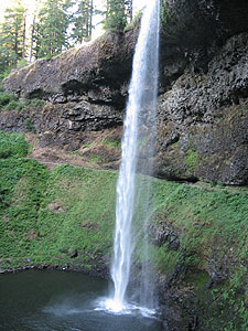 |
| Silver Creek Falls State Park |
Erratic Rock State Natural Site sits a ways off Highway 18 (between McMinnville and the coast). Here, a long walkway mysteriously leads up a hill, surrounded by lush countryside and farms, until it reaches only a big boulder. There, a plaque explains it’s a 40-ton rock that was dropped here during these prehistoric floods. Scientists know the flood brought it here because it is geologically not from the area – it’s of a type found only in Canada.
These erratics were often frozen into icebergs that drifted along these colossal waters. When the waters went away, the icebergs landed and melted, leaving only these boulders from foreign lands. The one at the park is the largest one found.
These erratics cause plenty of construction problems throughout the Willamette Valley, Yamhill County and the Portland area. They are buried beneath the ground in abundance, and construction crews have to remove all of them to finish their jobs.
The Erratic Natural Site is on Oldsville Road, just off Highway 18, near Sheridan.
The Missoula Flood even affected Marys Peak, near Corvallis. This, the highest point in the coast range, has a stunning patchwork of different ecosytems near its top. Sometimes even just an acre or two, patches of the mountaintop host incredibly different life forms from nearby patches – and many of these are plants or insect species otherwise extinct.
 |
| Oregon's wine country has plenty of evidence of the Missoula Floods |
What scientists believe is that the Missoula Flood scoured everything below a certain level, leaving certain plants and insects intact, which otherwise became extinct over time around the rest of the world.
There is some rather ominous evidence of this in the lore of local tribes. Some native tales handed down recount an enormous flood in the area of ultra-Biblical proportions – evidence that there were indeed humans who witnessed this event, and apparently were kept safe on top of Marys Peak.
Diamond Craters Natural Area – Southeast Oregon
About 55 miles SW of Burns, it’s a mix of desert and striking moonscape. While the average visitor will see just sagebrush and lonesome rock formations, the trained eye sees a Disneyland of geologic tales. It’s an area known by geologists to contain some of the most diverse geologic features in the world, all contained in a relatively small area.
Red Bomb Crater is among these. About 1,000 feet in diameter, it was the result of magma rising through layers of water, which caused it to explode in a shower of lava, rock and other things that formed what are called “bombs.”
One of these is “breadcrust bombs,” which you can now find in the form of rocks with zig-zagging lines in them, which are said to look like breadcrust. They also look a bit like dried cow-pies. So the spectacular thing about them is not what they look like, but rather the story behind them. As balls of lava shot up into the air during these eruptions, sometimes the outer layers would cool while in flight. The gases inside would then expand, causing that cooling skin to crack.
A visually more spectacular feature is Lava Pit Crater, which looks like the remnants of an old volcano. It is in fact the result of a well of lava creating a big molten lake, which during eruptions keeps overflowing, building layer upon layer of basalt rock. This lava lake drains through lava tubes and other structures formed by previous eruptions, eventually leaving a crater.
These eruptions and flows have left funky features, like terraces or waterfall-like objects. Numerous channels occupy the spot.
Also in the area is a lava tube cave, off Malheur Cave Road. From Burns, travel east-southeast along Highway 78 for about 65 miles, then take Malheur Cave Road and continue five miles to the cave.
|
